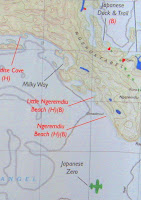
The Tourist Designated and Zoned Activity Areas map (pdf) was very useful in planning. Tourist activity in the Rock Islands is restricted to certain areas. (Don't worry, from what I saw all the nicest beaches were for tourist use.) The tourist areas have shelters and rest rooms.
Being a big Survivor fan I referred to Dan Bollinger's Survivor Maps. I wanted to stay on Exile Island (Kmekumer Island) but I was told that it was in the restricted Seventy Islands (aka Ngerkuid Islands Wildlife Preserve) where no one is allowed to enter. I was informed that Mark Burnett made a substantial contribution to be allowed to film there.
I also wanted to stay at the Malakal/Dabu tribal camp (Ngereblobang). I was looking forward to searching for what was left there (Survivor Fans vs. Favorites). Unfortunately, I was told that there was dangerous surf in the approach to that camp (on the east side of Mecherecher) so it would be too hazardous for me to kayak there. I did get to stay on Ulong Island.
This Soil Map , click on it to enlarge (link kindly provided by Barb Shaw) shows kayaking areas near Koror. Risong Bay is the big bay on the left side of the big blue island marked #9. On the right side of the island the bay with all the small islands is Nikko Bay.

Sam's Tours/Planet Blue Kayak Tours provides excellent maps with your kayak rental, with beaches and snorkeling spots indicated. Just be sure that they don't forget to give them to you.
Here's the Palau Visitors Authority Map of Koror (pdf). When you arrive in Palau you will be able to obtain a better, advertiser sponsored map.